Day 2 (Sunday 2 March 2014)
Visit to National Park Visitors Centre and La Cumbrecita
The weather was grey and cloudy when we left the hotel at 10am, but with patches of blue sky visible above the mountain ridge just to the west we hoped for fine weather later on. The coach took the same twisting road up the hillside as on the day before, and once through the road tunnel at the top of the climb we were met with a marvellous, virtually cloud-free sky with a fine view looking over to the west of the island.
The journey to the Visitors Centre took about 40 minutes. We stayed there for an hour or so before taking an early lunch, necessary to ensure we were punctual for our officially-allocated 2 hour time slot at La Cumbrecita.
Caldera de Taburiente National Park Visitors Centre
Here we saw large, informative displays of the geological history of La Palma and the Caldera in particular. This started with the island's origins some 3 million years ago as an underwater volcano whose base (the seamount) rose to the surface thanks to pressure from magma rising from below. The displays described the cycle of eruption and erosion which followed. An eruption on top of the seamount led to the creation of a substantial volcanic cone. This was then partially eroded when the eruption ceased but, later, fresh eruptions led to the creation of a new cone structure on the eroded remains of its predecessor. This cone too was then partially eroded away. This cycle seems to have been repeated several times, culminating in the creation of a 3,000 metre high stratovolcano. Eruptive volcanic activity in this part of the island then came to an end, but the instability of the accumulated debris on which the stratovolcano sat, combined with the actions of water flowing through the debris, led to its collapse some 500,000-560,000 years ago. This left behind the Caldera de Taburiente, an amphitheatre of splintered peaks around a space which is constantly growing as it is hollowed out by erosion.
Various publications were on sale in the Centre including a very informative, luridly-coloured geological map of the Caldera area. This was snapped up in good numbers by the group.
After the visit a sandwich lunch was taken in the shade of a nearby eucalyptus grove before setting off for La Cumbrecita.
La Cumbrecita
The 3-4 mile coach journey from the lunch stop was up a narrow forested valley, with good views behind us to the 'cloud waterfall'. The clouds, which had been amassing to the east of the mountain ridge in the morning, were now pouring over and down into the valley on the western side. A wonderful spectacle.
So too was the view from La Cumbrecita (1,287 metres), an outlook perched on the southern rim of the Caldera de Taburiente. From here we looked across to the far side of the amphitheatre, some 5-6 miles distant. The upper part of the slope is more or less vertical with differences in rock colour and strata clear to see, a record of the changes in eruption patterns over thousands of years.
Closer to hand, we looked up to the enormous vegetation-free dome of rock forming the Punta de los Roques (2,061 metres). This is composed of phonolite, a rock which is richer in alkali minerals and with less silica than other extrusive igneous rocks. The dome has survived as a prominent feature because phonolite is a hard, slabby rock with much more resistance to erosion than the rocks around it.
From the viewpoint at La Cumbrecita we took a short walk along the Caldera path to the viewpoint at Lomo de las Chozas during which we saw at first hand the very friable nature of much of the local rock. We saw pine trees on banks of soft, crumbly lava which was eroding away to leave tree roots just clinging on or else dangling free in the air. In a year or two these trees and the banks they cling to will be avalanche debris hundreds of feet below.
Other exposed banks were made of a stronger, more consolidated, lava material which is eroding more slowly. We saw a fine example of a lighter-coloured dyke intrusion in this rock which showed clearly the dark lines of contact metamorphosis on each side.
On this same walk, looking up we were able to see the stepped side of Pico Bejenado (1,845 metres) less than 2 miles away. The Pico is another phonolitic dome structure but there are trees on the stepped face in front of it. This face was in shade and could not be viewed in detail but it seemed to be made of a less solid material than the Pico itself. In time this face will erode away to add further to the widening of the Caldera, leaving behind a bare dome of rock.
At the Lomo de las Chozas viewpoint we looked down into the depths of the Caldera towards the Barranco de las Angustias, the ravine we had explored the day before and where we had seen exposures of the seamounts which underlie the entire Caldera structure. We had now seen the Caldera from both the bottom and from near the top - we would see it from the very top tomorrow.
This was the end of the day's tour. At 2:30pm we returned to the coach and descended the warm sunlit wooded valley while watching the smooth, mesmeric action of the cloud waterfall. We then headed back east through the road tunnel under the mountains, maybe looking forward to a cold beer and a swim in the hotel pool... only to emerge from the tunnel into a dull grey afternoon with temperatures at least 10C down on those we left behind. Note to organiser: use a hotel on the west side of the island next time! Note from organiser - no it will be easier to shift the trade winds.
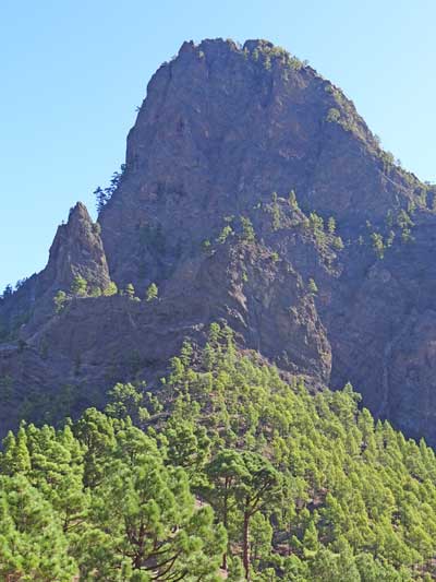
The caldera and a phonoloitic dome.
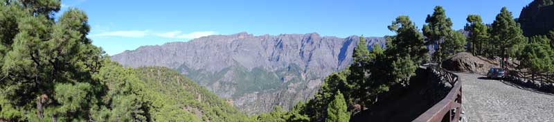
A panoramic view of Cumbreceita.
Robert Eveleigh